What it was like

I awoke just minutes prior to four this morning.  The sounds of driving rain, thunder, and violent winds heralded the arrival of our expected tempests.

Knowing the dangerous nature of this storm system and the threat it carried with it, I immediately checked NOAA’s site.  The first thing that grabbed my attention was the list of hazardous weather conditions:
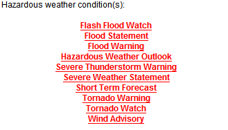
Hazardous weather conditions from NOAA for the morning of April 10, 2008

I certainly no longer felt sleepy at that point.  Seeing that and knowing the storm raged just outside, I felt it prudent to be fully awake and aware.

I quickly glanced at the current conditions.
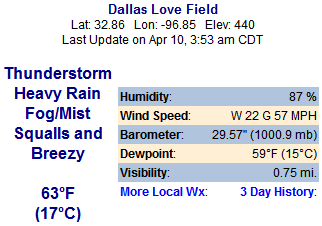
Weather conditions at four a.m. the morning of April 10, 2008

Seeing gusts of 57 mph (92 kph) seemed interesting, but then I read in the Severe Weather Statement that gusts above 80 mph (129 kph) had already been measured with these storms.  In fact, that bulletin included a warning that people should immediately move away from all windows until the storm had passed.

I then looked at the radar and satellite imagery, both of which told me the squall line had arrived directly over my location.
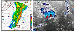
Radar and satellite imagery from the morning of April 10, 2008

All the while, heavy downpours fell as strong winds blew the precipitation with a strength of force that landed it at eye level against the patio doors and windows.  With it, a great deal of debris (small limbs, twigs and leaves) scurried about in the dark like some bizarre aerial ballet of detritus.

Lightning and thunder waltzed in beautiful displays of light and sound.  It felt like raw power streaming through the atmosphere.

The Tornado Warning indicated that problem existed north of me, so I expected little more than a severe thunderstorm—nothing unusual around these parts—followed by a gentle rain that would wind down by the time I had to go to work.

But that would not be the case.

As I fetched a drink of water and greeted The Kids, assuring each of them in turn that they had nothing to fear, a sudden change occurred.  It felt as though an abrupt increase of pressure happened inside the house.

I barely had time to stand and look at the patio doors and windows when it struck.

The impression was that of a massive solid force being wielded against the entire west wall, a wall of glass facing the patio, like a giant hammer of air slamming against the only protection we had from the intensity outside.

I could hear the doors creaking and bowing in under the assault, I could hear the rattle of windowpanes, I could sense an attack from the darkness.

Then windows broke and fell inward, the French doors in the living room snapped the top of the doorframe as the lock plate sprang from its anchors, and the feeling of impending doom fell over me like a cloak.

All of this took no more than a few seconds.

I immediately sprang into action, herding the cats into the bathroom with stern yet gentle tones and swift actions.  Huddled in that small space, we sat for perhaps ten minutes before I felt it safe enough to investigate.

What happened I cannot tell.  A microburst or downburst?  A straight-line wind zooming across the lake from the west until it struck my home on the eastern shore?  Something else?

Your guess is as good as mine.

What I do know is this:
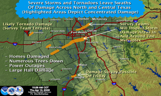
NOAA's preliminary damage map from the thunderstorms of April 10, 2008

That is NOAA’s preliminary damage map from this morning’s outbreak.  If you look closely at the longest line on the map, the one that runs from just south of Ft. Worth right toward the heart of Dallas, you should take note that its trajectory across Dallas County would have brought it directly to the White Rock Lake area.

Whether it was a tornado or a supercell generating destructive downburst, microburst, or straight-line winds, I suspect my experience in no small part can be blamed on that line of devastation.

Thankfully, my windows were replaced early this morning and the door repairs are being done now.  We should have a safe and secure home again within the next few hours.

Not everyone in North Texas can make the same claim.  Reports, videos and images from around the metroplex indicate we were assailed last night and this morning with widespread ferocity that destroyed homes, toppled trees, flipped cars and trucks like they were toys, made projectile weapons of anything not bolted down, knocked out power to hundreds of thousands of homes and businesses, and left the entire region bruised and battered.

While during the event I felt a great deal of apprehension and anxiety, especially for The Kids, afterward a certain excitement overtook me as I thought through what happened and how it was certainly a first-time event for me.

I respect nature.  I find great joy in seeing its power demonstrated.  Living within such a display can be frightening.  Afterward, though, all the excitement and awe in the world couldn’t explain how it feels.

We’re all gonna die…again!

The weather situation in North Texas is growing more precarious with each passing hour.  To wit (from NOAA):

THERE IS A MODERATE RISK OF SEVERE THUNDERSTORMS FOR MUCH OF NORTH TEXAS TONIGHT.

THUNDERSTORMS WILL CONTINUE TO DEVELOP THROUGH THE EVENING AND OVERNIGHT HOURS. TORNADOES…LARGE DESTRUCTIVE HAIL…AND WINDS IN EXCESS OF 60 MPH WILL BE POSSIBLE.

IN ADDITION TO THE SEVERE WEATHER THREAT…HEAVY RAINFALL IS FORECAST AND A FLASH FLOOD WATCH IS IN EFFECT FOR NORTHERN PORTIONS OF NORTH TEXAS. ADDITIONAL RAINFALL AMOUNTS OF 2 TO 4 INCHES WILL BE LIKELY.

Multiple tornadoes have already been reported, with at least one—if not two—still on the ground to the west moving east.

Hail to the size of baseballs has fallen across multiple counties, and this system is only now clearing its throat.  A temperature inversion (cap) has prohibited it from doing much until now, but that inversion is weakening as the storm strengthens.

A great deal of damage already has been reported west of here where confirmed tornadoes—rain shielded to hide the threat—have made rampaging runs across multiple counties.

The situation is expected to worsen overnight into tomorrow morning as a potent combination of circumstances provide ample fuel for severe storm development.

We’ll see how it goes.

WFAA endangers lives for marketing purposes

The e-mail I just sent to them:

Are you kidding?  In the middle of a severe weather outbreak, tornado warnings and severe thunderstorm warnings popping up all over the place, you ask me to register to view the local radar and/or weather page?

That’s endangerment, reckless and careless and selfish, and it deserves to be spread across the internet.

I don’t care that you ask for registration under most circumstances.  That’s why I don’t use your site very much and go elsewhere for news when you demand my personal information.

But during a severe weather outbreak?  Are you kidding?  You then want me to stop and provide all manner of details about me just so I can see if my life is in danger, if I need to take shelter?

It’s pitiful and pathetic at best.  It’s shameless without question.

For a news agency that likes to pretend it cares, this is a blatant contradiction to the “Family First” motto and the whole “we’re here for you” mentality that WFAA tries to sell.  In fact, it shows those are lies and deceptions perpetrated to extract marketing information from an audience that needs critical information when it counts, not registration forms.

[Update] This is even better than anything I could have written.  While their site demands I hand over all manner of personal information just so I can view the weather page and local radar information, their weather blog presents this headline: “New tornado warnings issued (6:51pm).”  It should also state that you can’t expect to actually see any of the critical, life-saving information unless you’re willing to file registration forms in triplicate, wait for a confirmation e-mail, and hope to hell you don’t die before you can complete the registration process.

[Update 2] These things just write themselves.  From WFAA’s own site, here are the most recent headlines: “Injuries reported in Breckenridge (7:13 pm)”; “65 mph winds in Parker County”; and “Tornado Warnings extended again (7:21pm).”  But you better register first if you want to know if you’re gonna die…

Buteo

A large hawk, one with broad wings that soars easily.  Thus is the definition of ‘buteo.’

And thus is the definition of this fine marvel, a splendid predator—albeit a juvenile—that I shared some time with on Saturday.

Walking along the eastern shore of White Rock Lake, I found myself surprised by the presence of a large hawk swooping across my path so near to me as to be touchable, reachable, an object of wonder that I might possess for a brief moment simply by holding my hand above my head.

This was our introduction.

I walked; it flew; we met.  I then gave chase, constantly fighting its tendency to move east of me, an action that placed me in the position of facing into the sun while trying to view and photograph this splendid creature.

A juvenile red-tailed hawk (Buteo jamaicensis) perched in a tree (20080405_02995)

A juvenile (most likely light-morph) red-tailed hawk (Buteo jamaicensis), its youthful appearance failed to hide its massive form.  I fell in awe as it swept by me just above my head, then I stalked it with abandon as it continued its attempts to outmaneuver the northern mockingbirds (Mimus polyglottos) that haunted it each time it came to rest on yet another perch.

A juvenile red-tailed hawk (Buteo jamaicensis) perched atop a tree (20080405_03031)

Like in the top of a tree where it could survey its surroundings.

But not for long.  Once a single mockingbird found it, several others responded to the herald for assistance and promptly swooped in to pester this beautiful creature.

So off it went…

A juvenile red-tailed hawk (Buteo jamaicensis) perched atop an electrical pole (20080405_03042)

Atop an electrical pole gave little respite from the avian onslaught that pursued it.  Not long after coming to rest there, the attack commenced again.  One mockingbird at first…

A juvenile red-tailed hawk (Buteo jamaicensis) perched atop an electrical pole while a northern mockingbird (Mimus polyglottos) taunts it from nearby (20080405_03052)

…several later.

Yet one is all it took to chase the raptor away.

A juvenile red-tailed hawk (Buteo jamaicensis) fleeing the onslaught of a northern mockingbird (Mimus polyglottos) (20080405_03053)

Finding refuge amongst the naked bones of the world, this fine hunter took but a moment to collect itself before dashing off to a safer retreat.

A juvenile red-tailed hawk (Buteo jamaicensis) taking flight from a barren tree (20080405_03069)

It flew far into the distance before rising on thermals, beginning a grand circle in the sky that carried it upward, away, into the blue ether that would grant it the wish it so longed for: safety and security while it hunted.

It’s mine!

Did you have a toy at sunset?  Was your evening filled with play that no one dared interrupt?  What happiness did you experience as the sun fell below the horizon, as you held firmly to a bit of catnip fun?

Kako gripping a catnip toy in the feeble light of sunset (20080223_02248)
Kako gripping a catnip toy in the feeble light of sunset (20080223_02273)

[Kako]